Day Eight
Monday, 09-06-04
Rising at 5:00 am we were on the road by 6:00 with a genuine purpose. First, we had a hankerin’ to see the sunrise from our next Station, which was somewhat higher in elevation. Secondly, we knew that this would be a long and very hot day and wished to get some miles behind us in the cool of the morning.
As we dropped down into the valley headed north from Whites City it was anything but warm. The temperature immediately fell 20 degrees and we road in semi-darkness into a 60 mile an hour breeze at about 50 degrees.
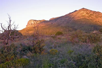
We arrived at the Pinery Station, N31° 53.591' W104° 49.110' before sunrise and I started in on making us some coffee. Guadalupe Peak shown golden above and behind us.
It was a sublime moment waiting for the sun to come down the mountain and warm us, coffee in hand and the rugged landscape reaching out before us as we stood next to the ruins.
From here we crest the mountain pass of the highest point in Texas,(8,751 ft) with a fabulous view of El Capitan.
On the far side of the mountain the Butterfield crossed north and west across a large salt flat to Crow Springs. I think for the more adventurous there might even be a trip across that desolation but Paul and I headed into Dell City to pick up the trail. Greene describes it well but it took us several tries to locate the road out of Dell City. This kind of searching is particularly tedious. We would go several miles down a road thinking it might be the one only to find ourselves riddled with doubt and headed into a very real “no man’s” land. Then at some point the doubt would build to overwhelming anxiety and we would turn around. Eventually, we overcame our Y chromosome weakness and went to the gas station in town to actually ask for directions.
As we got off our bikes a rather classic looking Indian man cautioned us to get out of the way of an oncoming pick up truck that crept slowly by, driven by an incredibly ancient looking Indian. There seemed to be plenty of room and when I raised an eyebrow to the first Indian he laughed and said, “He is just learning to drive, I wouldn’t trust him.” It was worth a laugh, I tell you. Then we asked this guy, his name was Eligio, who seemed to be the operator of the station about the Butterfield and about the road that we were hoping to find. I could tell Eligio knew exactly which road we were looking for, but was not encouraging us to actually find it. In fact, he said something like, “There ain’t much out there, maybe a ranch or two. It’s dirt you know? Pretty rough. If you two get lost you’ll have to send up a smoke signal.” I responded that maybe he would like to give us his telephone number in case we needed his help. He laughed, and then said with finality, “No, don’t call me. I only respond to smoke signals.” He was smiling, but he meant it. Then he proceeded to tell us how to find the beginning of what would be the longest gravel road I ever imagined. We topped off the bikes and followed his direction. Sure enough, we found ourselves a few miles out of town and stopped to consider our situation.
We had, up to now, every advantage of the would be modern day adventurer. Paul spent weeks entering into his GPS the routes I had been sending him. If I had had any skill with the dang thing it would have practically walked me by the hand from one Station to the next. We had all these magnificent satellites sailing overhead, relaying our exact position and suggesting, based on my notes, where we should go next. However, for some strange but perhaps calculated reason the Universe had pre-empted Paul’s intention and this particular loop of trail was missing entirely from our GPS data base.
On most areas of the trail this would not be significant. Here, however, we were presented with a particularly ignominious and archaic path. The Butterfield of 1858 simply did not care that it was about to launch across State borders into a section of the trail in New Mexico that would later be described as, “the sole remaining portion of the whole route between Tipton and San Francisco that is still virtually undisturbed and unaltered.” But we cared, because undisturbed and unaltered meant that there was virtually no reason to transit this desolate region unless you are seeking the Butterfield.
So, we were faced with a decision. We could press forward without our GPS directives and depend on my hard copy maps which were good but only as accurate as the accuracy of our known location. Which means, if we knew where we were at, we might be able to get where we were going.
“The sole remaining portion of the whole route between Tipton and San Francisco that is still virtually undisturbed and unaltered,” spoke with some intensity so with my topo map duct taped to the tank of the 750 and wishing we had topped off our water supplies as well as our gas tanks, I put a finger on where I thought we were and we headed out to where we hoped we were going, Cornudas de los Alamos Station. Our sole concession seemed to be that the GPS would track our wanderings and in the likely event that we should get lost we could always follow it back to Dell City. If, the batteries held.
Cornudas de los Alamos means the Horns of the Cottonwoods. This station is situated in the Cornudas Mountains. “The Horned Mountains.” It may be that this is a reference to El Diablo or maybe just to the rugged nature of the crags and peaks that shadow Thorne’s Well, a reliable water source nearby the Station. Whatever the intent, Cornudas Mountain stands guard over the only water in what looks like a thousand square miles.
The two liters of water we were carrying began to seem small, especially when the GPS went black. I taped it securely to avoid the vibration of the road and that seemed to help, but it did not inspire confidence.
Of course, water was a concern but it wasn’t long before the screeching of my front fork reminded me that I had other problems.
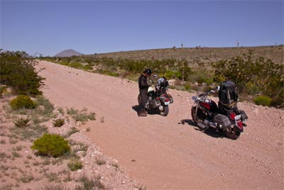
Every time I hit a new crater in the road my front fork made a new and ever more plaintive cry for fluids. Oh yeah, that little fork problem. Brother Paul had recently taken the lead. Spurred on most probably by the prospect of eating dust for what we had calculated would be about 60 miles of dirt and gravel road.
He was amazing. Having lost all caution regarding his brand new 1100, he literally flew above the washboard curves and sailed over the cow-sized potholes in the road. I think he had finally convinced himself that a kind of zen-like abandon was his only hope. A complete mind-releasing and childlike ecstasy seemed to overcome him. I couldn’t keep up. And I was the one with the map.
As we proceeded through mile after mile of endless expanse without the interruption of one simple out building or barn I believe he had an epiphany of trust. I know I did, but it was brought on more by the steady mantra like acknowledgement that kept being repeated by my front fork . “This is no longer in your hands,” it seemed to squeak at me with each plunging dive into the next dry creek bed. Cornudas Mountain below:
Somewhere near the Cornudas Ranch is Thorne’s Well and the Cornudas Station N32° 5.163' W105° 31.149'
I remember at some point thinking that we should get a picture of Thorne’s Well. Somehow though, the thought of actually turning off the bikes was something that both Paul and I agreed was akin to mutually assured destruction. As long as neither of us stopped, or more importantly, as long as neither of us actually turned off our bikes, well then, it was implied that we would keep going and thus would succeed. I do regret now that our terror kept us from a more languid enjoyment and documentation of our progress across this desolation.
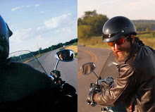
Yet, Paul was able, granted he did not turn off his bike, to take this photo. It speaks of thousands of miles frozen in one small rectangular frame.
I remember passing the Cornudas Ranch but I don’t remember the next station which is called Ojos de los Alamos, Eyes of the Cottonwoods, which are springs in a mountain about half a mile from the road and sixteen miles past Cornudas. Ojos de los Alamos Station, N32° 4.856' W105° 44.025' remains. waiting for another day.
We rode on, finger to the map and eyes on the rising horizon that displayed what we guessed was the Cerro Alto Mountain and the gap to the right above, led to Hueco Tanks.
There is no longer access to the Hueco Tanks through private land but the trail went that way. We went south to highway 62 and west. Hueco Tanks State Historical Park is a popular climbers spot and we felt sure we could get access from the west side of the mountain.
I must say that I have not given enough emphasis to the feelings of great relief and accomplishment that accompanied our arrival at highway 62. We both knew that so much that could have gone wrong had not gone wrong and that Our Lady of Guadalupe must have other fates in mind for us besides mummification at the side of the road in the Cornudas Mountains. Yet, relief was tempered by the fact that it was still about 98 degrees and we had yet to actually see a building much less a cold drink.
We headed to Hueco Tanks Station, N31° 54.608' W106° 1.657' .
Arriving at Hueco Tanks State Historical Park was a relief. It was a mixed relief, however. On the one hand there was A.C.. On the other there were rules. The rules we found could eventually be supplanted. In the meantime we indulged in a cold drink from the machine. To say we were grateful for this respite would ignore the prostration and murmured prayers and promises we made to the creator deity in the form of a coke machine. It was more like we were smitten with a degree of respectful piety. This respect, however, did not extend to the park employee that insisted on giving us detailed instruction on the rules and regulation of the park. These included a prohibition against getting out of our vehicles, (dismounting in our case) in order to take a picture of the Station that was admittedly located within the park. In order to do this we would be obliged first to sit through a 30 minute video which detailed in more exacting description the rules of the park already eluded to by the park employee.
Needless to say, Paul was having none of that. We retired again to the soothing presence of the most holy coke machine to consider our options and drink a cold libation. We were in agreement. There was no way we were going to sit through a half hour of abuse. However, it seemed that a strict interpretation of the rules might lend us some success if the Butterfield Station was visible from the road. We agreed to try our luck.
I believe we paid some modest fee for a drive through, got on our bikes and proceeded into the park. Below is the fruit of our effort and the reward of our accommodation to the rules. Good enough for me.
Having accomplished our objective we made our egress. The trail followed a southwest route from the park but we elected to go back the way we came and follow the highway into El Paso.
Franklin Station, N31° 45.405' W106° 29.322' is well described by Greene and located precisely. It covered nearly an entire city block. The station building, with a twelve-arch façade, fronted 112 feet on El Paso Street. “Other than the name of the street and historical markers there is no trace of the Butterfield installations.” Paul and I decided that rather than endure the big city traffic any more than necessary we would take the bypass and head out of town expeditiously, which we did.
Heading north into New Mexico, again, we followed Interstate 10 through La Tuna. Cotton Wood Station, N31° 58.857' W106° 35.427' is located 350 feet northwest of the Santa Fe railroad station at La Tuna. La Tuna is a State Correctional Facility. Advisedly, one should avoid that. We did.
We were excited to try to find the next station. Known as Mesilla Station, N32° 16.207' W106° 48.049' it held promise for the Butterfield adventurer. Research indicated that it was still standing and had been converted to a restaurant and bar. Only a mile and half off I-10 La Mesilla, the town, offered an amazing time warp back to the 1850’s. The entire square seemed composed of original buildings in fantastic condition.
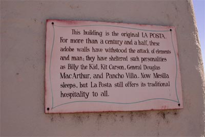
As if guided by the hand of Providence we found a parking place immediately behind the location we sought, La Posta. La Posta was a complex of buildings which included the original station and housed a restaurant and a collection of shops.
We strolled in and walked past a line of patrons waiting patiently for a table. We were mostly after the ambience but found ourselves eventually standing in front of a classic western-style bar. Now, Paul and I had sort of an incontrovertible rule that beer was relegated to the non-driving hours of the day. Somehow, though, the situation begged for a reconsideration. We sauntered up to the bar, which is the only way one can appropriately approach a bar in the wildy west and inquired of the barkeep if he could accommodate us with a beer if we took a standing position there in the trafficked way of the busy restaurant. He was most agreeable, so we ordered, in deference to our commitment to sobriety, a lite beer. Sipping our frosty mugs we asked him if he could enlighten us to the whereabouts of the actual Butterfield Station.

With a dramatic sweep of his arm he referenced a stained glass window behind him. “This, he said, was the original entrance to the Station.” We stood with froth dripping from our moustaches in amazement. To our left was a beautiful painting of the Stagecoach coming into the Station and indeed it depicted the very place where we stood..
It was a most excellent beer we shared. There is something about a moment like this that can not be improved by discourse. Paul, being the sage that he is, knew enough to keep it sacred. We drank our beers in silence. One beer had been our agreed transgression so we tipped the barkeep and made our way to the door.

Outside we assessed the square and located our interior position.
 I had Paul take this picture of the building. The third window above the blue car is the original door.
La Mesilla deserves a much more attentive exploration. It is a beautiful and charming place with a well preserve historic square. Our quest called us to the road instead and we road regretfully from town. In hindsight, perhaps we should have looked for accommodations there. Instead, we blew down Interstate 10 like we were late for a committee meeting.
New Mexico has some of the best documented and located stations along the Butterfield Trail. Unfortunately, there are no through roads so that any station requires considerable back tracking. One must, by necessity, go down Highway 10 to a north bound road and then turn 15 to 30 miles north to find the stations which are well marked on the topographic maps. Of course this requires then an equal regress back to the highway.
Picacho Station
Cooke’s Spring Station
Cow Sprngs Station
And Soldier’s Farewell Station all represented a possibility of fabulous exploration and delight.
Unfortunately, we now could feel the weight of time and it pressed down on us even more so than the exhaustion of the desert sun. We made the choice to pass these stations and head to Lordsburg.
After 2 hours of Interstate driving we pulled into the town of Lordsburg , made famous in John Wayne’s classic movie “Stagecoach” and we were too beat to even locate the station which was shown on the map as Barney’s Stage Station, N32° 20.445' W108° 39.465'. Instead we found the Best Western and went down. A long hard day. 340 miles. This doesn’t sound far but on the Cornudas Mountain road we averaged about 20 miles an hour. We felt nearly dead, but not dead enough to skip the beer run. Corona’s iced in the sink we settled down to post some pictures.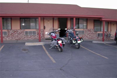
Rising at 5:00 am we were on the road by 6:00 with a genuine purpose. First, we had a hankerin’ to see the sunrise from our next Station, which was somewhat higher in elevation. Secondly, we knew that this would be a long and very hot day and wished to get some miles behind us in the cool of the morning.
As we dropped down into the valley headed north from Whites City it was anything but warm. The temperature immediately fell 20 degrees and we road in semi-darkness into a 60 mile an hour breeze at about 50 degrees.
We arrived at the Pinery Station, N31° 53.591' W104° 49.110' before sunrise and I started in on making us some coffee. Guadalupe Peak shown golden above and behind us.
It was a sublime moment waiting for the sun to come down the mountain and warm us, coffee in hand and the rugged landscape reaching out before us as we stood next to the ruins.

From here we crest the mountain pass of the highest point in Texas,(8,751 ft) with a fabulous view of El Capitan.

On the far side of the mountain the Butterfield crossed north and west across a large salt flat to Crow Springs. I think for the more adventurous there might even be a trip across that desolation but Paul and I headed into Dell City to pick up the trail. Greene describes it well but it took us several tries to locate the road out of Dell City. This kind of searching is particularly tedious. We would go several miles down a road thinking it might be the one only to find ourselves riddled with doubt and headed into a very real “no man’s” land. Then at some point the doubt would build to overwhelming anxiety and we would turn around. Eventually, we overcame our Y chromosome weakness and went to the gas station in town to actually ask for directions.
As we got off our bikes a rather classic looking Indian man cautioned us to get out of the way of an oncoming pick up truck that crept slowly by, driven by an incredibly ancient looking Indian. There seemed to be plenty of room and when I raised an eyebrow to the first Indian he laughed and said, “He is just learning to drive, I wouldn’t trust him.” It was worth a laugh, I tell you. Then we asked this guy, his name was Eligio, who seemed to be the operator of the station about the Butterfield and about the road that we were hoping to find. I could tell Eligio knew exactly which road we were looking for, but was not encouraging us to actually find it. In fact, he said something like, “There ain’t much out there, maybe a ranch or two. It’s dirt you know? Pretty rough. If you two get lost you’ll have to send up a smoke signal.” I responded that maybe he would like to give us his telephone number in case we needed his help. He laughed, and then said with finality, “No, don’t call me. I only respond to smoke signals.” He was smiling, but he meant it. Then he proceeded to tell us how to find the beginning of what would be the longest gravel road I ever imagined. We topped off the bikes and followed his direction. Sure enough, we found ourselves a few miles out of town and stopped to consider our situation.
We had, up to now, every advantage of the would be modern day adventurer. Paul spent weeks entering into his GPS the routes I had been sending him. If I had had any skill with the dang thing it would have practically walked me by the hand from one Station to the next. We had all these magnificent satellites sailing overhead, relaying our exact position and suggesting, based on my notes, where we should go next. However, for some strange but perhaps calculated reason the Universe had pre-empted Paul’s intention and this particular loop of trail was missing entirely from our GPS data base.
On most areas of the trail this would not be significant. Here, however, we were presented with a particularly ignominious and archaic path. The Butterfield of 1858 simply did not care that it was about to launch across State borders into a section of the trail in New Mexico that would later be described as, “the sole remaining portion of the whole route between Tipton and San Francisco that is still virtually undisturbed and unaltered.” But we cared, because undisturbed and unaltered meant that there was virtually no reason to transit this desolate region unless you are seeking the Butterfield.
So, we were faced with a decision. We could press forward without our GPS directives and depend on my hard copy maps which were good but only as accurate as the accuracy of our known location. Which means, if we knew where we were at, we might be able to get where we were going.
“The sole remaining portion of the whole route between Tipton and San Francisco that is still virtually undisturbed and unaltered,” spoke with some intensity so with my topo map duct taped to the tank of the 750 and wishing we had topped off our water supplies as well as our gas tanks, I put a finger on where I thought we were and we headed out to where we hoped we were going, Cornudas de los Alamos Station. Our sole concession seemed to be that the GPS would track our wanderings and in the likely event that we should get lost we could always follow it back to Dell City. If, the batteries held.
Cornudas de los Alamos means the Horns of the Cottonwoods. This station is situated in the Cornudas Mountains. “The Horned Mountains.” It may be that this is a reference to El Diablo or maybe just to the rugged nature of the crags and peaks that shadow Thorne’s Well, a reliable water source nearby the Station. Whatever the intent, Cornudas Mountain stands guard over the only water in what looks like a thousand square miles.
The two liters of water we were carrying began to seem small, especially when the GPS went black. I taped it securely to avoid the vibration of the road and that seemed to help, but it did not inspire confidence.
Of course, water was a concern but it wasn’t long before the screeching of my front fork reminded me that I had other problems.

Every time I hit a new crater in the road my front fork made a new and ever more plaintive cry for fluids. Oh yeah, that little fork problem. Brother Paul had recently taken the lead. Spurred on most probably by the prospect of eating dust for what we had calculated would be about 60 miles of dirt and gravel road.
He was amazing. Having lost all caution regarding his brand new 1100, he literally flew above the washboard curves and sailed over the cow-sized potholes in the road. I think he had finally convinced himself that a kind of zen-like abandon was his only hope. A complete mind-releasing and childlike ecstasy seemed to overcome him. I couldn’t keep up. And I was the one with the map.
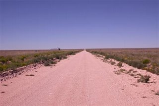
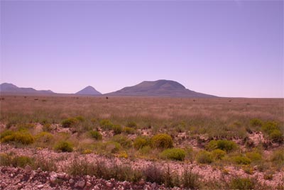
As we proceeded through mile after mile of endless expanse without the interruption of one simple out building or barn I believe he had an epiphany of trust. I know I did, but it was brought on more by the steady mantra like acknowledgement that kept being repeated by my front fork . “This is no longer in your hands,” it seemed to squeak at me with each plunging dive into the next dry creek bed. Cornudas Mountain below:
Somewhere near the Cornudas Ranch is Thorne’s Well and the Cornudas Station N32° 5.163' W105° 31.149'
I remember at some point thinking that we should get a picture of Thorne’s Well. Somehow though, the thought of actually turning off the bikes was something that both Paul and I agreed was akin to mutually assured destruction. As long as neither of us stopped, or more importantly, as long as neither of us actually turned off our bikes, well then, it was implied that we would keep going and thus would succeed. I do regret now that our terror kept us from a more languid enjoyment and documentation of our progress across this desolation.
Yet, Paul was able, granted he did not turn off his bike, to take this photo. It speaks of thousands of miles frozen in one small rectangular frame.

I remember passing the Cornudas Ranch but I don’t remember the next station which is called Ojos de los Alamos, Eyes of the Cottonwoods, which are springs in a mountain about half a mile from the road and sixteen miles past Cornudas. Ojos de los Alamos Station, N32° 4.856' W105° 44.025' remains. waiting for another day.
We rode on, finger to the map and eyes on the rising horizon that displayed what we guessed
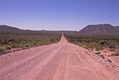 was the Cerro Alto Mountain and the gap to the right above, led to Hueco Tanks.
There is no longer access to the Hueco Tanks through private land but the trail went that way. We went south to highway 62 and west. Hueco Tanks State Historical Park is a popular climbers spot and we felt sure we could get access from the west side of the mountain.
I must say that I have not given enough emphasis to the feelings of great relief and accomplishment that accompanied our arrival at highway 62. We both knew that so much that could have gone wrong had not gone wrong and that Our Lady of Guadalupe must have other fates in mind for us besides mummification at the side of the road in the Cornudas Mountains. Yet, relief was tempered by the fact that it was still about 98 degrees and we had yet to actually see a building much less a cold drink.
We headed to Hueco Tanks Station, N31° 54.608' W106° 1.657' .
Arriving at Hueco Tanks State Historical Park was a relief. It was a mixed relief, however. On the one hand there was A.C.. On the other there were rules. The rules we found could eventually be supplanted. In the meantime we indulged in a cold drink from the machine. To say we were grateful for this respite would ignore the prostration and murmured prayers and promises we made to the creator deity in the form of a coke machine. It was more like we were smitten with a degree of respectful piety. This respect, however, did not extend to the park employee that insisted on giving us detailed instruction on the rules and regulation of the park. These included a prohibition against getting out of our vehicles, (dismounting in our case) in order to take a picture of the Station that was admittedly located within the park. In order to do this we would be obliged first to sit through a 30 minute video which detailed in more exacting description the rules of the park already eluded to by the park employee.
Needless to say, Paul was having none of that. We retired again to the soothing presence of the most holy coke machine to consider our options and drink a cold libation. We were in agreement. There was no way we were going to sit through a half hour of abuse. However, it seemed that a strict interpretation of the rules might lend us some success if the Butterfield Station was visible from the road. We agreed to try our luck.
I believe we paid some modest fee for a drive through, got on our bikes and proceeded into the park. Below is the fruit of our effort and the reward of our accommodation to the rules. Good enough for me.

Having accomplished our objective we made our egress. The trail followed a southwest route from the park but we elected to go back the way we came and follow the highway into El Paso.
Franklin Station, N31° 45.405' W106° 29.322' is well described by Greene and located precisely. It covered nearly an entire city block. The station building, with a twelve-arch façade, fronted 112 feet on El Paso Street. “Other than the name of the street and historical markers there is no trace of the Butterfield installations.” Paul and I decided that rather than endure the big city traffic any more than necessary we would take the bypass and head out of town expeditiously, which we did.
Heading north into New Mexico, again, we followed Interstate 10 through La Tuna. Cotton Wood Station, N31° 58.857' W106° 35.427' is located 350 feet northwest of the Santa Fe railroad station at La Tuna. La Tuna is a State Correctional Facility. Advisedly, one should avoid that. We did.
We were excited to try to find the next station. Known as Mesilla Station, N32° 16.207' W106° 48.049' it held promise for the Butterfield adventurer. Research indicated that it was still standing and had been converted to a restaurant and bar. Only a mile and half off I-10 La Mesilla, the town, offered an amazing time warp back to the 1850’s. The entire square seemed composed of original buildings in fantastic condition.
As if guided by the hand of Providence we found a parking place immediately behind the location we sought, La Posta. La Posta was a complex of buildings which included the original station and housed a restaurant and a collection of shops.
We strolled in and walked past a line of patrons waiting patiently for a table. We were mostly after the ambience but found ourselves eventually standing in front of a classic western-style bar. Now, Paul and I had sort of an incontrovertible rule that beer was relegated to the non-driving hours of the day. Somehow, though, the situation begged for a reconsideration. We sauntered up to the bar, which is the only way one can appropriately approach a bar in the wildy west and inquired of the barkeep if he could accommodate us with a beer if we took a standing position there in the trafficked way of the busy restaurant. He was most agreeable, so we ordered, in deference to our commitment to sobriety, a lite beer. Sipping our frosty mugs we asked him if he could enlighten us to the whereabouts of the actual Butterfield Station.

With a dramatic sweep of his arm he referenced a stained glass window behind him. “This, he said, was the original entrance to the Station.” We stood with froth dripping from our moustaches in amazement. To our left was a beautiful painting of the Stagecoach coming into the Station and indeed it depicted the very place where we stood..
It was a most excellent beer we shared. There is something about a moment like this that can not be improved by discourse. Paul, being the sage that he is, knew enough to keep it sacred. We drank our beers in silence. One beer had been our agreed transgression so we tipped the barkeep and made our way to the door.
Outside we assessed the square and located our interior position.
 I had Paul take this picture of the building. The third window above the blue car is the original door.
La Mesilla deserves a much more attentive exploration. It is a beautiful and charming place with a well preserve historic square. Our quest called us to the road instead and we road regretfully from town. In hindsight, perhaps we should have looked for accommodations there. Instead, we blew down Interstate 10 like we were late for a committee meeting.
New Mexico has some of the best documented and located stations along the Butterfield Trail. Unfortunately, there are no through roads so that any station requires considerable back tracking. One must, by necessity, go down Highway 10 to a north bound road and then turn 15 to 30 miles north to find the stations which are well marked on the topographic maps. Of course this requires then an equal regress back to the highway.
Picacho Station
Cooke’s Spring Station
Cow Sprngs Station
And Soldier’s Farewell Station all represented a possibility of fabulous exploration and delight.
Unfortunately, we now could feel the weight of time and it pressed down on us even more so than the exhaustion of the desert sun. We made the choice to pass these stations and head to Lordsburg.
After 2 hours of Interstate driving we pulled into the town of Lordsburg , made famous in John Wayne’s classic movie “Stagecoach” and we were too beat to even locate the station which was shown on the map as Barney’s Stage Station, N32° 20.445' W108° 39.465'. Instead we found the Best Western and went down. A long hard day. 340 miles. This doesn’t sound far but on the Cornudas Mountain road we averaged about 20 miles an hour. We felt nearly dead, but not dead enough to skip the beer run. Corona’s iced in the sink we settled down to post some pictures.

posted by Don and Paul Matt at 2:32 PM
0 comments
![]()